
Page 1 of 2
| Network West Midlands SimSig map of mine 22/03/2012 at 02:07 #30826 | |
|
Underwood
748 posts |
Hello all, I have created a Network West Midlands fake SimSig map, hopefully it looks like a real sim as that is the intention. For those who use the train simulator BVE or OpenBVE, then you would know what NWM is. It is a fictional route set in the Midlands, but it does feel real at the same time. The map of mine is still W.I.P but it has a lot done to it, I just need to work on the Maybank end and Hammerwich end, and some decorations in between. Note I have coloured auto signals and left manual ones red. There is no yellows shown at the moment, as that will be the final thing to add. Also, I don't know if I have auto's with emergency plungers in the right places, I don't know where these are generally located to be honest, I can't see them just being installed at random places? I might need some semi-auto's added in but I have some in at locations that would more likely have them. I have attached the W.I.P map as a zip so you can open with picture viewer to zoom in or use MS paint for the detailed, clearer view. I did try uploading it as an image but it is unreadable and you can't zoom in. Hope you like it so far, I will keep you up to date with progress. Cheers, James. [attachment=280]NWM_WMC_SimSig.zip[/attachment] Post has attachments. Log in to view them. Log in to reply |
| Re: Network West Midlands SimSig map of mine 22/03/2012 at 03:42 #30827 | |
|
Josie
310 posts |
James, this is fantastic, brilliant work! It's been a little while since I've played NWM so I might be wrong but I think there's an up signal in the down platform at Radley Junction (I seem to recall one of the diagrams terminating there, although I might be making that up completely). You've also shown the Salford Bridge works as wired and the turnback siding as unwired, instead of the other way round. But really this is amazing, and I can't wait to see it when it's finished :-)
Log in to reply |
| Re: Network West Midlands SimSig map of mine 22/03/2012 at 04:47 #30828 | |
|
Jsun
212 posts |
double post
Last edited: 22/03/2012 at 05:16 by Jsun Reason: redundant Log in to reply |
| Re: Network West Midlands SimSig map of mine 22/03/2012 at 04:55 #30829 | |
|
Jsun
212 posts |
Well done indeed. Would have been interesting to know what's on the other side of the station since it has it's own box it would presumably have a few routes on the other side. The up automatic preceding the home at Frankly junction just before the tunnel would most likely have an emergency replacement no? Also the signal at the end of the Riverside up goods is approach lit.
Log in to reply |
| Re: Network West Midlands SimSig map of mine 22/03/2012 at 05:15 #30830 | |
|
Jsun
212 posts |
Seems like a bit of a task if you're intending to get to Ludgate Hill.
Log in to reply |
| Re: Network West Midlands SimSig map of mine 22/03/2012 at 10:36 #30831 | |
|
kbarber
1779 posts |
" said:Hello all, Nice looking piece of work. Don't know NWM so I've no idea whether the separate bits join up somewhere or not. So far as emergency replacements are concerned, I have an idea the standard used to be that one in five autos should be fitted if there was a run longer than that. Additionally, there should be one in rear of a tunnel (or other potential hazard - you might well site one for an embankment with a history of movement, for example, and usually one in rear of automatic level crossings). In practice those particular requirements would be met first, then the 1-in-5 would be fitted in between, perhaps with a nod to lesser potential risks (so a run of 16 autos might be done as 1-in-4, 2 X 5 + 2 (or 3) or 3-4-5 or whatever, according to what seemed most appropriate at the time). Again, it's a case of using NWM to find out exactly what you're running past/through to give the best idea where there might be hazards outside the fence and provide accordingly. Following Uff-Cullen I think the requirement became that every auto should have emergency replacement - a much easier task with SSI and VDU input than with relay-driven signals and pushbutton/switch panels, where there was often nothing but TC indications in the controlling signalbox. But of course there's still an awful lot of old kit out there and it's going to be a while before the new standard applies universally. Hope this is useful. Log in to reply |
| Re: Network West Midlands SimSig map of mine 22/03/2012 at 12:11 #30833 | |
|
Late Turn
699 posts |
Just one comment - where you've got a shunt route out to a Limit of Shunt (as at Maybank, out wrong-road towards Maybank Tunnel), that should be protected by a controlled signal (not an auto signal as currently indicated). One or two locations look like they ought to have reduced overlaps, or have facing points within the overlap - in both cases, the signal in rear should be controlled too (respective examples being coming off the branch at Clifton Greenbridge, and approaching Riverside from Kings Road). Good effort though!
Log in to reply |
| Re: Network West Midlands SimSig map of mine 22/03/2012 at 13:29 #30834 | |
|
Underwood
748 posts |
Thank you for the responses and the fault finding :) I will modify them before I carry on, there was some other mistakes I put in there before, like full auto's at junctions :blush: but changed that after I noticed! Your right about the signal at Radley Junction too, being used for terminator trains there is indeed a signal there, don't know how I passed it in Route Viewer. I also forgot about the approach lit signal at Riverside too! Thank's for spotting that out. I will modify the emergency signals too though I'll probably sort that out last when I change the colours of signals to yellows for those approaching reds, and modify the limit of OHLE at Salford Bridge too. As for what is beyond Maybank, I have no idea but I won't add anything beyond. Where the line ends is where it stops in the NWM Quail map. I shall probably finish just beyond Hobbs Cross too where local boxes take over. I have yet to sort out panels too, these would probably be as per PSB boundary. Cheers, James. Log in to reply |
| Re: Network West Midlands SimSig map of mine 22/03/2012 at 22:14 #30841 | |
|
Lardybiker
771 posts |
Interesting.....I don't use BVE but I had a look to see what you'd done just out of interest. Nice job so far. I noted a couple of things that, were you following the SimSig style guide, would be deemed not quite right. Some may seem a bit picky particularly as its only a representation so feel free to incorporate or ignore as you see fit!! having said that we at SimSig do like things to be right.....Anyway, here's what I spotted. 1) Manually controlled crossings - RAI is the preferred name for raise rather than RSE 2) Crossovers such as Roundway Jn, normally show all the track (the straight and the diagonal) unless a route is set across or the crossover is not fixed but actually 2 separate sets of points. If they are separate single points, the diagonals between the running lines need to be moved (for Roundaway that would be a bit to the left) to ensure the diagonals are offset (like at Whitminster Jn). If it is a fixed crossover, you should depict the straight and the angled tracks. 3) The first signal on the up fast at Salford Jn would typically have a berth. This would normally be shown as the 4 berth characters + 2 normal track characters either side at minimum. The hollow track prior to the signal is thus a tad too close so either move the signal right a bit or extend the normal track a bit further left. 4) The shunt signal at I expect should line up with the break between the hollow track and the normal track...It would need moving a bit to the right (see Maybank Carriage sidings as that one is correct). They are several other instance of this as well (HS at Whitminster, all the sidings at Whiminster CS, Salford Dn Sidgs ,and Norton CS) 5)The up siding at Whitminster appears to have a TRTS. That would rather unusual. 6) The TRTS symbols at Whiminster would likely be on the platforms to avoid confusion. You can show them with a full white circle. 7) The siding between the running lines at Frankley Jn should have more space above it. You should have at least 1 blank line between any horizontal track lines. 8) Any loops should be at least 2 lines away fromt he main running lines to differentate them 9) The label Up Goods at franklin is a little confusing as its not clear which line its referring to. I suspect its the upper one so you should move it so that its above that line. 10) the U&D GL at Norton would probably have direction of flow indicators on it as it bi-directional. Last edited: 22/03/2012 at 22:16 by Lardybiker Log in to reply The following user said thank you: Underwood |
| Re: Network West Midlands SimSig map of mine 23/03/2012 at 10:44 #30846 | |
|
Underwood
748 posts |
" said:Interesting.....I don't use BVE but I had a look to see what you'd done just out of interest. Nice job so far. I noted a couple of things that, were you following the SimSig style guide, would be deemed not quite right. Some may seem a bit picky particularly as its only a representation so feel free to incorporate or ignore as you see fit!! having said that we at SimSig do like things to be right.....Anyway, here's what I spotted.Hello Chris (Sorry, it is Chris isn't it? :blush:) Thank you for your interest, it certainly hasn't been a 5 minute job! As you say it is a rep map and thus for me I never really followed any guidelines if there are any, so I researched from other simulations. I will answer what I can though: Quote: 1) Manually controlled crossings - RAI is the preferred name for raise rather than RSEAh yes, so I just noticed! The buttons were actually copied from Exeter Stoke Cannon LC on SimSig, which has RSE but I notice RAI is used too. I may change this if RAI is more common? Quote: 2) Crossovers such as Roundway Jn, normally show all the track (the straight and the diagonal) unless a route is set across or the crossover is not fixed but actually 2 separate sets of points. If they are separate single points, the diagonals between the running lines need to be moved (for Roundaway that would be a bit to the left) to ensure the diagonals are offset (like at Whitminster Jn). If it is a fixed crossover, you should depict the straight and the angled tracks.You mean the gaps between points and lines? If so yes I was wondering weather these should actually be filled in, as at the time the track section was taken last year when I used to use SimSig with 'show point positions' on, but now I don't use it. I assume a layout wouldn't show all positions unless a route is set like you say? If so I can change this without causing issues. Quote: 3) The first signal on the up fast at Salford Jn would typically have a berth. This would normally be shown as the 4 berth characters + 2 normal track characters either side at minimum. The hollow track prior to the signal is thus a tad too close so either move the signal right a bit or extend the normal track a bit further left.There is a berth there however I assume you mean the Berth box should be moved back for room for track sections? Unfortunately I do not know the character size as this was a copy/paste entry section as all are copied/pasted from 'print screen' screenshots into MS paint. Otherwise would the berth box be above the line or does that not matter? Quote: 4) The shunt signal at I expect should line up with the break between the hollow track and the normal track...It would need moving a bit to the right (see Maybank Carriage sidings as that one is correct). They are several other instance of this as well (HS at Whitminster, all the sidings at Whiminster CS, Salford Dn Sidgs ,and Norton CS)The shunt signal...which one? There is a few hundred on there  So for the C.S should they line up equally? Quote: 5)The up siding at Whitminster appears to have a TRTS. That would rather unusual.I did wonder if I put the TRTS in the right place, as it is for the Down Bay but looks like it's for the HS at the same time. Quote: 6) The TRTS symbols at Whiminster would likely be on the platforms to avoid confusion. You can show them with a full white circle.I wondered if I should put them there as I didn't quite know if they would be there. I just copied the style from Exeter and Newton Abbot. Also, I might need yellow triangles for the Up line? 7) The siding between the running lines at Frankley Jn should have more space above it. You should have at least 1 blank line between any horizontal track lines. Quote: 8) Any loops should be at least 2 lines away fromt he main running lines to differentate themDo you mean like the Up/Down Goods at Riverside, U&DGL at Stiffs Hill (Clifton Greenbridge), Up/Down goods at Frankley Junction etc? I got the loop spacing from Westbury sim, however now I look at other sims, these are spaced out by two lines whereas mine copies Westbury. I can change these however if that is the correct way? Quote: 9) The label Up Goods at franklin is a little confusing as its not clear which line its referring to. I suspect its the upper one so you should move it so that its above that line.I assume you mean Frankley :P, anyway yes I can move this above, what would be the spacing between that and the station name label? Quote: 10) the U&D GL at Norton would probably have direction of flow indicators on it as it bi-directional.Ah yes didn't think about that! There should be one at Clifton Greenbridge Stiffs Hill U&DGL too. Thank you very much for your time and input for analysing the map :). It is something I have never put together before and took a hell of a long time to paste sections together. Even the labels are copy/paste jobs and jumbled together to make the name. I am also hoping of creating another scenario after I have finished with trains on the map to bring it alive! Cheers, James. Log in to reply |
| Re: Network West Midlands SimSig map of mine 23/03/2012 at 16:59 #30849 | |
|
Jan
925 posts |
" said:Quote:2) Crossovers such as Roundway Jn, normally show all the track (the straight and the diagonal) unless a route is set across or the crossover is not fixed but actually 2 separate sets of points. If they are separate single points, the diagonals between the running lines need to be moved (for Roundaway that would be a bit to the left) to ensure the diagonals are offset (like at Whitminster Jn). If it is a fixed crossover, you should depict the straight and the angled tracks.You mean the gaps between points and lines? If so yes I was wondering weather these should actually be filled in, as at the time the track section was taken last year when I used to use SimSig with 'show point positions' on, but now I don't use it. I assume a layout wouldn't show all positions unless a route is set like you say? If so I can change this without causing issues. To further complicate things, there are switched diamonds (is that the UK term?) as well, which are shown on the diagram the way you've done it now. They are used when to crossing angle gets too shallow for a fixed crossing to be used, and possibly in some other circumstances as well. Two million people attempt to use Birmingham's magnificent rail network every year, with just over a million of them managing to get further than Smethwick. Log in to reply |
| Re: Network West Midlands SimSig map of mine 23/03/2012 at 17:37 #30851 | |
|
headshot119
4871 posts |
" said:" said:I think we call them "slips" at least in the modeling world.Quote:2) Crossovers such as Roundway Jn, normally show all the track (the straight and the diagonal) unless a route is set across or the crossover is not fixed but actually 2 separate sets of points. If they are separate single points, the diagonals between the running lines need to be moved (for Roundaway that would be a bit to the left) to ensure the diagonals are offset (like at Whitminster Jn). If it is a fixed crossover, you should depict the straight and the angled tracks.You mean the gaps between points and lines? If so yes I was wondering weather these should actually be filled in, as at the time the track section was taken last year when I used to use SimSig with 'show point positions' on, but now I don't use it. I assume a layout wouldn't show all positions unless a route is set like you say? If so I can change this without causing issues. "Passengers for New Lane, should be seated in the rear coach of the train " - Opinions are my own and not those of my employer Log in to reply |
| Re: Network West Midlands SimSig map of mine 23/03/2012 at 17:49 #30852 | |
|
Underwood
748 posts |
Ah I see now yes, they should be filled in with straight lines as there is no slip intentional. Thank you for the explanation 
Log in to reply |
| Re: Network West Midlands SimSig map of mine 23/03/2012 at 18:04 #30853 | |
|
jc92
3746 posts |
single and double slips are a crossover with either one or two turnouts combined. a swtich diamond is where there are effectively two turnouts back to back, whose soul purpose is to provide either a crossover, or a through run. woodhouse jcn still has one of these as does (i think) one of the carmuirs boxes "We don't stop camborne wednesdays" Log in to reply |
| Re: Network West Midlands SimSig map of mine 23/03/2012 at 19:06 #30855 | |
|
Lardybiker
771 posts |
Headshot, I am afraid you are referring to something else. Jan is correct and using the correct terminology. There are typically 4 types of crossings..... 1) Fixed - there is no moving parts and trains travel diagonally or straight across them with no option to diverge. 2) Switched diamond - Identical to (1) with no diversions but has movable rails within the crossing. The rails move to select either the horizontal route or the diagonal route. 3) Slip crossing - Combines a fixed crossing and some points so trains can diverge from diagonal line to straight and vice versa. Can be single just one direction, called a single slip or on both sides, called a double slip. 4) The last type isn't so much of a crossing but more sets of individual points to allows trains to switch from one line to another... You may also be able to combine (2) and (3) as well. In modelling you hardly ever see (2) its normally (1) or (3). In SimSig, all the above are drawn differently... 1) Shows all tracks through the crossing when unused. When a route is set through it, show a straight peice of track (either horizontal or diagonal). 2) Drawn as 2 points back to back. 3) Look at the throat of Kings Cross station...That has multiple slip crossings..Its easier than trying to explain... 4) As there are separate points they are usually draw with the points with at least 1 normal track element between them otherwise you can;t distinguish them from a switched diamond. Log in to reply |
| Re: Network West Midlands SimSig map of mine 23/03/2012 at 19:10 #30856 | |
|
Lardybiker
771 posts |
James, Its really difficult to describe some of what I said so if you want to PM me, I can e-mail you back some images which may make what I wrote an awful lot more sense.... Log in to reply |
| Re: Network West Midlands SimSig map of mine 23/03/2012 at 19:11 #30857 | |
|
headshot119
4871 posts |
" said:Headshot,Yeah I think I'm getting confused. "Passengers for New Lane, should be seated in the rear coach of the train " - Opinions are my own and not those of my employer Log in to reply |
| Re: Network West Midlands SimSig map of mine 23/03/2012 at 22:27 #30864 | |
|
BoxBoyKit
166 posts |
Looks rather good! Shame it's not a sim  hint hint hint hint  although I believe that's been covered elsewhere? although I believe that's been covered elsewhere?One criticism I have though, is the "Up Starting" from the UGL at Riverside. It should be hollow, as it only displays an aspect when a route is set to/from it, or there is a train standing at it. If you look at it when driving any train straight along the main, you'll notice it dispalys no aspect. There is a signal on the Gloucester sim like this, and I think another but I can't remember. Log in to reply |
| Re: Network West Midlands SimSig map of mine 23/03/2012 at 23:44 #30865 | |
|
Signalhunter
177 posts |
I like this. I used to play on BVE a lot, until my Windows XP laptop died. BVE doesn't work on Vista.
Log in to reply |
| Re: Network West Midlands SimSig map of mine 24/03/2012 at 01:11 #30866 | |
|
Josie
310 posts |
" said:I like this. I used to play on BVE a lot, until my Windows XP laptop died. BVE doesn't work on Vista.May I strongly recommend OpenBVE (sometimes known as Train Sim Framework)? I run it without any problems on Windows 7. NWM is in fact only supporting OpenBVE now, as it uses newer features which aren't available in BVE2/4. Log in to reply |
| Re: Network West Midlands SimSig map of mine 24/03/2012 at 21:45 #30875 | |
|
Sam Tugwell
494 posts |
Theres some technical wizardry that can definately allow BVE 4 to run on Windows 7, so I presume it could be done on Windows Vista
"Signalman Exeter" Log in to reply |
| Re: Network West Midlands SimSig map of mine 24/03/2012 at 21:50 #30876 | |
|
headshot119
4871 posts |
The issue with running BVE or OBVE on Windows Vista or 7 is 64bit, works fine on 32bit.
"Passengers for New Lane, should be seated in the rear coach of the train " - Opinions are my own and not those of my employer Log in to reply |
| Re: Network West Midlands SimSig map of mine 24/03/2012 at 22:01 #30877 | |
|
Sam Tugwell
494 posts |
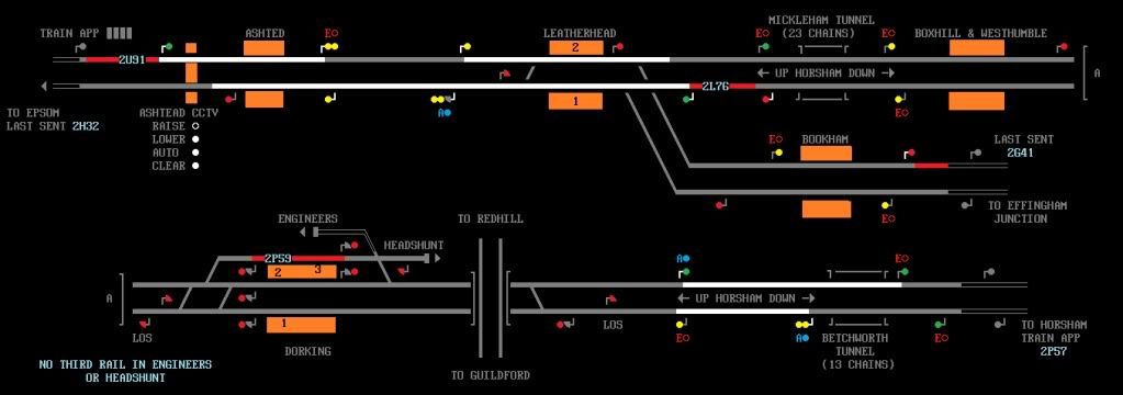
Heres one ive done for Leatherhead and Dorking area. Not a real signal box area covered. Thoughts and opinions welcomed. http://i1161.photobucket.com/albums/q503/SamTugwell/LeatherheadandDorking.jpg "Signalman Exeter" Log in to reply |
| Re: Network West Midlands SimSig map of mine 24/03/2012 at 22:38 #30880 | |
|
jc92
3746 posts |
ive dug up an old diagram i did of barnsley PSB and WCS. a couple of signals are shown incorrectly here, i have a better fully accurate one with TCs included as WIP
Post has attachments. Log in to view them. "We don't stop camborne wednesdays" Log in to reply |
| Re: Network West Midlands SimSig map of mine 24/03/2012 at 22:42 #30881 | |
|
CTCThiago
232 posts |
Great Map... I play NWM on Openbve... that panel on SimSig, will be fantastic! CTC. Log in to reply |